What are the major Revolutionary War battle sites in the U.S.?
Major Revolutionary War battle sites across the U.S. include Saratoga, New York; Yorktown, Virginia; Valley Forge, Pennsylvania; Bunker Hill, Massachusetts; and Trenton, New Jersey. These locations preserve significant historical landscapes and often feature visitor centers with maps, exhibits, and educational programs. Many are maintained by the National Park Service, offering detailed directions and visitor information. Planning a visit allows direct engagement with the war's geography.
How can I get directions to Revolutionary War historical parks?
To get directions to Revolutionary War historical parks, use online mapping services like Google Maps or directly visit the National Park Service (NPS.gov) website. Search for specific parks like "Saratoga National Historical Park directions." The NPS site provides detailed visitor information, including operating hours, accessibility, and specific driving instructions. Confirm these details before your visit, as seasonal adjustments or special events may impact access or hours of operation.
Where can I buy accurate maps of the American Revolution?
You can buy accurate maps of the American Revolution from reputable sources such as museum gift shops at historical sites like the Museum of the American Revolution, specialized online historical map retailers, and major book retailers with history sections. Check for publishers known for historical cartography like National Geographic or university presses. Always verify the source's reputation to ensure historical accuracy and quality. Online reviews can guide your purchase decisions effectively.
What online resources offer free Revolutionary War maps?
Several excellent online resources offer free Revolutionary War maps. The Library of Congress (loc.gov) and the National Archives (archives.gov) provide extensive digital collections of historical maps, often in high resolution. University libraries and historical societies like the David Rumsey Map Collection also make vast numbers of historical maps freely accessible. These platforms are invaluable for research, education, and general interest, offering diverse cartographic views of the conflict.
Are there guided tours for Revolutionary War battlefields near me?
Many Revolutionary War battlefields offer guided tours, often led by park rangers or historical interpreters. To find tours near you, search online for the specific battlefield's official website or the National Park Service website. These sites list tour schedules, availability, and contact information. Some local historical societies also provide specialized tours. Checking reviews and booking in advance is often recommended, especially during peak travel seasons, ensuring a richer visit experience.
Revolutionary War map, American Revolution battle map, historical war maps for sale, colonial era maps US, Revolutionary War sites directions, best maps of 1776 battles, find Revolutionary War history near me, interactive Revolutionary War map, Revolutionary War museum maps, original Revolutionary War mapsDiscover the pivotal maps of the American Revolutionary War and trace the footsteps of history. This comprehensive guide helps U.S. searchers navigate historical battlefields, understand strategic movements, and locate authentic resources. Learn where to find detailed Revolutionary War maps, from digital archives to physical museum collections, enhancing your understanding of America's fight for independence. Explore how these crucial documents reveal troop positions, campaign routes, and significant engagements, offering unparalleled insights for students, educators, and history enthusiasts alike. We highlight top destinations and online platforms to access these invaluable cartographic treasures, helping you plan visits to historic sites or conduct in-depth research. Uncover what to know before you visit a battlefield, how to interpret these antique maps, and where to purchase high-quality replicas. This resource provides essential guidance to deepen your connection to the Revolutionary War, ensuring you find the best map resources available to inform your next historical journey or study project.
- What was the main purpose of Revolutionary War maps? - Revolutionary War maps primarily served military purposes, detailing troop movements, fortifications, and strategic geographic features crucial for planning campaigns. They also documented battle outcomes and evolving territorial control, providing invaluable historical records for later study and preservation.
- Where can I view original American Revolutionary War maps? - Original American Revolutionary War maps are preserved in various institutions, including the Library of Congress, National Archives, British Library, and numerous state historical societies. Many of these institutions offer digital access to their collections online, allowing remote viewing of rare and significant cartographic documents.
- How accurate are historical Revolutionary War battle maps? - Historical Revolutionary War battle maps vary in accuracy, reflecting the surveying techniques and wartime conditions of their creation. While some were meticulously drafted by skilled cartographers, others were hastily sketched. Modern historians and cartographers often cross-reference multiple sources to establish the most precise interpretations of historical events and locations.
- Can I visit sites depicted on Revolutionary War maps? - Yes, many sites depicted on Revolutionary War maps are preserved as national historical parks, state parks, or local landmarks across the United States. Visitors can explore battlefields like Yorktown, Saratoga, and Valley Forge, often with interpretive centers and guided tours that bring the maps to life. Check local park websites for details.
- What role did maps play in military strategy during the Revolution? - Maps were indispensable for military strategy during the Revolution, enabling commanders to assess terrain, plan troop deployments, identify supply routes, and anticipate enemy movements. George Washington, for instance, relied heavily on detailed maps provided by his cartographers to make critical decisions that shaped the course of the war.
- Are there educational resources using Revolutionary War maps for kids? - Many educational resources utilize Revolutionary War maps to engage younger audiences. Websites, history books, and museum programs often feature simplified or interactive maps to teach about key events, figures, and geographical significance. These tools make complex historical narratives accessible and exciting for students.
The Map Of The American Revolutionary War provides an invaluable lens through which we can explore the foundational conflict that shaped the United States. These maps are not merely geographical representations; they are dynamic records of military strategy, troop movements, and the unfolding drama of a nation's birth. For U.S. searchers, understanding these maps offers a profound connection to our past, revealing the critical decisions and challenging terrains that defined the fight for independence. Whether you are a history enthusiast, a student, or planning a historical tour, delving into these maps unlocks a deeper appreciation for the sacrifices and triumphs of the Revolutionary era. This guide will help you navigate the landscape of Revolutionary War cartography, showing you where to find these essential historical documents and how they illuminate the events of 1775-1783.
Engaging with Revolutionary War maps transcends simple rote memorization of facts and dates. It offers a visual, tangible link to the struggles faced by both American and British forces. These cartographic artifacts allow us to visualize troop deployments, understand the strategic significance of key locations like Saratoga, Yorktown, and Valley Forge, and trace the challenging supply lines that sustained armies. From intricate battle plans to broader campaign maps, each document tells a unique story, providing insights into the logistical complexities and tactical brilliance that characterized the war. Preparing to explore these maps means preparing to immerse yourself in the very heart of American history, understanding its geographical underpinnings.
Today, access to these historical maps is more abundant than ever, thanks to extensive digitalization efforts and dedicated historical institutions. You can find everything from high-resolution digital scans of original maps to carefully reproduced replicas and interactive online platforms. This article serves as your definitive resource, guiding you to the best places for discovery. We will cover where to locate these maps, how to interpret their historical details, and what practical steps you can take to incorporate them into your studies or travel plans. Join us as we explore the crucial role of the Map Of The American Revolutionary War in preserving and understanding America's fight for freedom, offering a comprehensive look at their significance for a modern U.S. audience.
Where Can I Find Accurate Revolutionary War Battle Maps?
Locating accurate maps of the American Revolutionary War is a rewarding pursuit for anyone interested in American history. Various institutions and online platforms dedicate themselves to preserving and sharing these invaluable historical artifacts. For those seeking genuine historical context, consulting reputable sources ensures the information you gather is trustworthy and meticulously researched. Many major historical societies and government archives have digitized vast collections, making them accessible from anywhere in the U.S. These digital repositories often provide high-resolution images, allowing for detailed examination of the intricate artistry and information contained within each map, bringing the past directly to your screen with incredible clarity.
Exploring Digital Archives
The Library of Congress and the National Archives are premier destinations for exploring Revolutionary War maps online. Their extensive digital collections feature thousands of maps, including original survey maps, military plans, and topographical charts from the period. These archives offer not just scans of the maps, but often include detailed metadata, historical context, and provenance information. You can search by battle, year, or even specific cartographer, providing an unparalleled research experience. Utilizing these resources allows historians, students, and enthusiasts to delve deep into specific events and campaigns, seeing the war through the eyes of those who charted its course.
Beyond national institutions, numerous state historical societies and university libraries also host significant collections relevant to local Revolutionary War events. For example, the New York Historical Society or the Massachusetts Historical Society often hold maps detailing battles and campaigns specific to their regions. Browsing these specialized digital archives can uncover unique perspectives and less-known cartographic treasures. These localized collections frequently provide detailed information about troop movements and engagements that might not be prominently featured in broader national collections. Exploring these local resources is crucial for understanding regional impacts of the war.
Interactive online map projects, such as those by academic institutions or historical foundations, offer dynamic ways to experience Revolutionary War cartography. These platforms often overlay historical maps onto modern satellite imagery, allowing users to visualize how the landscape has changed over centuries. Such tools provide an engaging and educational experience, making complex geographical and historical information readily understandable. Users can often zoom in on battle formations, trace historical roads, and identify key landmarks, transforming static historical data into an immersive learning journey. These interactive maps are particularly beneficial for educational purposes, helping students grasp complex concepts.
Visiting Historical Sites and Museums
For a tangible connection to the past, visiting museums and historical sites across the U.S. offers an unparalleled experience. Institutions like the Museum of the American Revolution in Philadelphia, the Boston Tea Party Ships & Museum, or the Colonial Williamsburg Foundation frequently display original or high-quality replica maps. These exhibits provide context, often accompanied by artifacts and interpretive information that bring the maps to life. Seeing these maps in person, sometimes just steps from the actual battlegrounds they depict, creates a powerful and memorable educational opportunity, allowing visitors to visualize history unfolding before their eyes.
Many national and state historical parks, established on actual Revolutionary War battlefields, also feature visitor centers with extensive map displays. For example, at Saratoga National Historical Park or Valley Forge National Historical Park, you can find detailed maps illustrating the encampments, troop movements, and decisive moments of these pivotal locations. Park rangers and educational materials often explain the maps' significance and guide visitors through the landscapes they represent. This direct engagement with the physical location, paired with the historical maps, offers a comprehensive understanding of the battles' geographical impact and strategic importance, truly immersing you in the historical context.
Before planning your visit, it is highly recommended to check the specific museum or park website for current hours, admission fees, and exhibit details. Many sites offer guided tours that incorporate discussions of the maps, providing expert insights into their historical relevance. Some might even have gift shops where you can purchase high-quality reproductions of historical maps, perfect for personal study or decoration. Engaging with these sites offers a unique opportunity to connect directly with the past, seeing how the landscapes documented in the maps influenced the unfolding narrative of America's fight for independence, making history tangibly real.
How Do Revolutionary War Maps Aid Historical Understanding?
Revolutionary War maps are indispensable tools for historians, educators, and anyone seeking a deeper understanding of this pivotal period in American history. These maps provide a crucial visual dimension that text-based accounts alone cannot fully convey, transforming abstract narratives into concrete geographical realities. By examining these historical documents, we gain insights into the logistical challenges, strategic thinking, and environmental factors that profoundly influenced the war's outcome. They allow us to contextualize events, appreciate the scale of military operations, and comprehend the interconnectedness of various campaigns across the fledgling United States.
Visualizing Key Campaigns
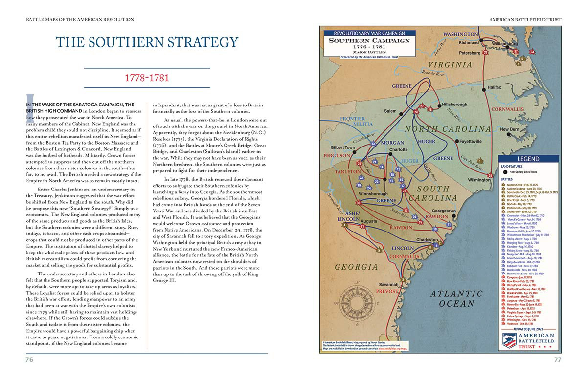
Maps of the American Revolutionary War vividly illustrate the complexities of major campaigns, such as the New York and New Jersey Campaign or the Southern Campaign. They plot the routes of armies, showing how forces maneuvered across varied terrains, highlighting the importance of rivers, mountains, and coastal access. For instance, studying a map of the Saratoga campaign reveals the intricate movements that led to Burgoyne's surrender, detailing the British advance and the American defensive positions. This visualization helps us grasp the tactical brilliance and the sheer physical effort involved in prosecuting a war across a vast and often undeveloped continent, making the history much more accessible.
These maps also clarify the ebb and flow of control over significant territories throughout the conflict. By comparing maps from different phases of the war, one can observe the shifting lines of British and American influence, understanding how battles altered the political and military landscape. For example, maps documenting the occupation of major cities like Philadelphia or New York offer clear insights into the challenges of maintaining control and the resilience of the American spirit. This dynamic view of territorial shifts underscores the prolonged and arduous nature of the struggle for independence, illustrating the constant push and pull between the warring factions.
Furthermore, campaign maps frequently include details beyond mere troop locations, often depicting fortifications, supply depots, and strategic transportation networks. These elements are vital for understanding the logistical nightmares and strategic priorities of both sides. Examining a map showing the supply routes to Valley Forge, for instance, illuminates the immense difficulties faced by the Continental Army during that brutal winter encampment. These detailed graphical representations humanize the history, reminding us of the practical realities and desperate circumstances under which soldiers fought and endured, providing a more complete picture of the wartime experience.
Understanding Strategic Significance
The strategic significance of specific locations becomes profoundly clear when viewed through the lens of Revolutionary War maps. For example, maps of the Hudson River Valley reveal its critical importance as a natural barrier and transportation artery, explaining why both sides fought fiercely for its control. Similarly, coastal maps highlight the vital role of naval power and port cities for British supply lines and American privateering efforts. These geographical insights are essential for appreciating the decisions made by commanders and political leaders, showing how terrain and access shaped military doctrine.
Maps also aid in understanding the broader geopolitical context of the war, showcasing not just domestic conflicts but also the involvement of foreign powers. Some maps illustrate the routes of French naval fleets or the areas of Spanish and Dutch influence, demonstrating how the American Revolution was part of a larger global struggle. This expanded perspective helps to contextualize the alliances and diplomatic efforts that ultimately contributed to American victory. Seeing these international dimensions visually reinforces the notion that the American Revolution was a pivotal moment on the world stage, drawing in numerous global actors.
Moreover, by studying battle plans, we gain an appreciation for the innovative tactics and traditional military strategies employed by generals like George Washington, Nathanael Greene, and Lord Cornwallis. Maps of battles such as Trenton, Princeton, or Cowpens meticulously detail troop formations, flanking maneuvers, and retreat paths. These visual records demonstrate how commanders adapted to terrain and enemy movements, showcasing their brilliance or miscalculations. Analyzing these strategic elements through maps fosters a deeper critical understanding of military history and the art of warfare during the 18th century, offering lessons that resonate even today in strategic thinking.
What Are the Best Ways to Use Revolutionary War Maps for Education?
Revolutionary War maps are powerful educational tools that can transform how students and lifelong learners engage with American history. Their visual nature makes complex historical events more accessible and memorable, offering a dynamic alternative to traditional textbook learning. Incorporating these maps into educational settings helps students develop critical thinking skills, spatial reasoning, and a nuanced understanding of historical context. By actively interpreting the geography of the conflict, learners can connect more deeply with the challenges and decisions faced by the people of the 18th century, fostering a richer educational experience.
Educational Resources for Students
For students, Revolutionary War maps can serve as primary source documents for historical inquiry. Educators can assign projects where students analyze specific battle maps, identifying troop movements, geographical advantages, and key strategic points. This encourages active learning and helps students develop a sense of historical empathy by imagining themselves in the shoes of commanders or soldiers. Many online educational platforms and museums offer lesson plans and activities specifically designed around these maps, making them easy for teachers to integrate into their curriculum, creating a more engaging classroom environment for all.
Interactive online maps are particularly effective for engaging younger students. Websites often provide animated maps that illustrate the progression of battles or campaigns over time, allowing students to visualize the dynamic nature of the war. These digital tools can feature clickable points providing information about specific events, people, or locations, transforming passive viewing into an active exploration. Utilizing these cutting-edge resources ensures that history lessons remain vibrant and relevant for a generation comfortable with digital interfaces, promoting deeper engagement with historical content in an intuitive way.
Furthermore, maps can be used to teach geography in conjunction with history. Students can learn about the thirteen colonies' borders, significant rivers, mountain ranges, and coastal areas as they relate to military campaigns. This interdisciplinary approach strengthens geographical knowledge while simultaneously deepening historical understanding. Projects involving tracing routes or identifying present-day locations on historical maps can make these connections even more concrete, showing how past geographies influence current landscapes. This holistic approach ensures a comprehensive education that integrates various academic disciplines seamlessly.
Planning Historical Tours
For families, educators, or individuals planning historical tours, Revolutionary War maps are indispensable guides. Before visiting a battlefield or historical site, studying relevant maps provides crucial context, helping visitors understand the significance of specific landmarks and terrain features. Knowing the positions of forces at Bunker Hill or the layout of the encampment at Valley Forge before arrival profoundly enhances the experience, allowing for a more informed and meaningful exploration of these hallowed grounds. These maps effectively serve as an itinerary to the past, guiding visitors through the historical narrative.
Many historical parks and museums provide updated maps that combine historical data with modern navigational information. These specialized maps can highlight walking trails, interpretive markers, and key points of interest, ensuring visitors don't miss any vital aspects of the site. Some apps even offer GPS-enabled tours that overlay historical maps onto your live location, making it feel like you are walking through history itself. Always check the park or museum's official website for visitor information, including hours, accessibility, and any specific guidance on utilizing maps during your visit, guaranteeing a smooth and informative experience.
Consider purchasing high-quality replica maps from museum gift shops or specialized historical map retailers. These serve as excellent souvenirs and valuable educational resources for continued study at home. Having a physical map allows for closer examination of details and serves as a constant reminder of the incredible history you explored. Engaging with these maps, whether digitally or physically, transforms a simple trip into an immersive historical journey, fostering a deeper appreciation for the Map Of The American Revolutionary War and its lasting legacy on the United States. These tangible reminders help solidify the memories and lessons learned from the historical sites.
FAQs about Revolutionary War Maps
What was the most significant battle of the American Revolution?
The Battle of Saratoga, fought in 1777, is widely considered the most significant battle of the American Revolution. This decisive American victory convinced France to officially ally with the United States, providing crucial military and financial support. Saratoga demonstrated the Continental Army's capability to defeat a major British force, fundamentally altering the course and outcome of the war. Its impact extended internationally, securing vital foreign aid.
Where can I purchase authentic replica Revolutionary War maps?
You can purchase authentic replica Revolutionary War maps from various sources. Museum gift shops at historical sites like the Museum of the American Revolution or Colonial Williamsburg often carry high-quality reproductions. Specialized online retailers focusing on historical cartography, such as Old World Auctions or historical map archives, also offer a wide selection. Always check for reputable dealers known for accuracy and quality of reproduction. These sources ensure you receive historically faithful and visually appealing replicas.
Are there interactive online maps of the Revolutionary War?
Yes, numerous interactive online maps of the Revolutionary War are available. Institutions like the National Park Service, the Library of Congress, and various university history departments host digital projects that allow users to explore campaigns, battles, and troop movements dynamically. These platforms often feature historical overlays, timelines, and clickable information points. Such interactive tools provide an engaging and educational experience, making complex historical geography accessible to a broad audience for better comprehension.
Revolutionary War maps are not just historical documents; they are powerful educational tools that connect us directly to the birth of our nation. By exploring these intricate maps, whether through digital archives or on-site visits, you gain a profound appreciation for the strategic genius, immense challenges, and pivotal moments that defined the American Revolution. These maps unlock a deeper understanding of the sacrifices made and the landscapes transformed in the fight for independence. We encourage you to seek out these invaluable resources, enhancing your knowledge and fostering a more personal connection to this defining period.
Whether you are planning a trip to a battlefield near you, conducting academic research, or simply curious about America's past, leveraging the power of Revolutionary War maps is an essential step. Remember to utilize trusted sources like the Library of Congress, local historical societies, and well-curated museum exhibits. Before visiting any physical location, always check their official websites for current operating hours, directions, and any specific guidance for map-related inquiries. These proactive steps ensure a rewarding and informative experience, allowing you to trace history's contours with confidence.
Ultimately, engaging with the Map Of The American Revolutionary War is an enriching journey that deepens your appreciation for the complex interplay of geography and human endeavor. These maps offer a visual narrative that complements written accounts, bringing the stories of courage, strategy, and perseverance to life. Take the opportunity to explore these cartographic treasures and let them guide your understanding of America's fight for freedom. The insights gained from these historical documents will undoubtedly empower you to see the past not as a distant memory, but as a vibrant, tangible force that continues to shape our present and future, driving a continuous desire to learn.
American Revolutionary War maps meaning, historical battle maps locations, best Revolutionary War maps for students, where to buy replica Revolutionary War maps, tracing Revolutionary War routes, Revolutionary War battle sites near me, interactive Revolutionary War maps online, comparing historical war maps


American Revolution Facts Battles Founding Fathers More PBS Battle Map Clean Making Maps Under Fire During The Revolutionary War National Geographic 02MAPS Atlas Of And Campaigns 1775 1783 HELION1000293 Watch A Every Day Brilliant Media QWXA DEB233W 4e4f4ac8 6A9C 41DA BF6A CF0F011409B3 DEB233W 4e4f4ac8 6A9C 41DA BF6A CF0F011409B3 World History Encyclopedia 17652 ABT158 2026 ABT158 2026 M ABT158 2026 9592069 Side RE01020603A Large RE01020603A Ten Great Institute Carte Des Etats Unis De Lamerique Lattre Paris 1784 SOC Detail 1784 Printable CB9934D1 B138 46e2 AB01 078d0e4fb726 CB9934D1 B138 46e2 AB01 078d0e4fb726 7TH Grade Humanities 116623 Orig 116623.


Atlas Of The Battles And Campaigns American Revolution 1775 1783 HELION1000297 Theaters Revolutionary War Indetheatersmap In North West 1776 1780 MAD MAPS Revolutionarywar Web Preview Ten Great Institute Cantonment His Majestys Forces N America 1766 By Daniel Paterson Detail LC 1766 Battle ABT158 Battlefield ABT158 A2 ABT158 A2 Map 1766 Drawing Fine Art 1766 ABT158 ABT158 M1 ABT158 M1 At A Glance Kids Britannica Homework Help 261036 049 0b8fa4d9 261036 049 0b8fa4d9 Book 9798994747704 Xlg 9798994747704 Interactive D224874BB65D1B7E369DC01262D44FD3 ABT158 ABT158 A1 ABT158 A1 ABT158 ABT158 A3 ABT158 A3.


Map Of Battles The American Revolutionary War Webquest 4186433 Outset Civil 1861 Thecollector Territories Us 1861 Large 1861 Action On Breed S Hill Drawing By Breeds Unknown Artist Ten Great Maps Revolution Institute Carte Du Theatre De La Guerre Michel Capitaine Chesnoy 1780 Detail 1780 In Union County Using Pension Records Amrev Sketch Engagement At Trenton Andreas Wiederholdt Ca 1776 LC 1776 A New Western Parts Thomas Hutchins 1778 JCB 1778 Museum PT2IMG24 Image 070722 Costofrevolution British Armys Route To Philadelphia PT2IMG24 070722 Faden Plan Battle Bunkers Sayer Bennett London 1775 SOC 1775 1757 Scaled 1757.